
Terkini Dan Ambil Perhatian! Ribut Tropika Sonamu Menuju Malaysia
NASA Catches Tropical Storm Sonamu in South China Sea


Text Credit: Rob Gutro
NASA's Goddard Space Flight Center
-THE SUN-


Dikeluarkan pada pukul 08:59PM, 06 Januari 2013
AMARAN KATEGORI KETIGA
AMARAN ANGIN KENCANG DAN LAUT BERGELORA
Di Perairan Laut China Selatan
Kemaskini:
Ribut Tropika (SONAMU) dikesan pada Latitud 7.5 U dan Longitud 109.3 T, pada jam 8:00 malam 6 Januari 2013, kira-kira 718 km ke Timur Laut Dungun, Terengganu dan bergerak ke arah Barat dengan perlahan.
SEKSYEN A : AMARAN ANGIN KENCANG DAN LAUT BERGELORA (KATEGORI KETIGA) - Kemaskini
Angin kencang Timur Laut dengan kelajuan dari 60 kmsj dengan ketinggian ombak melebihi 4.5 meter yang berlaku di kawasan perairan Kelantan, Terengganu, Samui, Condore, Reef North, Layang-Layang & Palawan dijangka berterusan sehingga Isnin, 7 Januari 2013.
Selain daripada itu, kawasan pantai di Kelantan & Terengganu terdedah kepada kejadian kenaikan paras air laut. Keadaan ini dijangka berterusan sehingga Isnin,7 Januari 2013.
Keadaan angin kencang dan laut bergelora ini berbahaya kepada semua aktiviti pantai dan perkapalan termasuk pekerja di pelantar minyak.
SEKSYEN B: AMARAN ANGIN KENCANG DAN LAUT BERGELORA (KATEGORI KEDUA)-Kemaskini
Angin kencang Timur Laut dengan kelajuan 50-60 kmsj dengan ombak mencapai ketinggian sehingga 4.5 meter yang berlaku di kawasan perairan Pahang, Johor Timur, Sarawak(Rejang, Mukah, Bintulu & Miri), WP Labuan, Sabah(Pedalaman, Pantai Barat & Kudat), Tioman & Reef South dijangka berterusan sehingga Jumaat, 11 Januari 2013.
Selain daripada itu, kawasan pantai di Pahang & Johor Timur terdedah kepada kejadian kenaikan paras air laut. Keadaan ini dijangka berterusan sehingga Isnin, 7 Januari 2013.
Keadaan angin kencang dan laut bergelora ini berbahaya kepada semua aktiviti perkapalan dan pantai termasuk menangkap ikan dan perkhidmatan feri.
SEKSYEN C: AMARAN ANGIN KENCANG DAN LAUT BERGELORA (KATEGORI PERTAMA)-Kemaskini
Angin kencang Timur Laut dengan kelajuan 40-50 kmsj dengan ombak mencapai ketinggian sehingga 3.5 meter yang berlaku di kawasan perairan Sarawak(Kuching), Sabah(Sandakan), Bunguran & Sulu dijangka berterusan sehingga Jumaat, 11 Januari 2013.
Keadaan angin kencang dan laut bergelora ini adalah berbahaya kepada bot-bot kecil, rekreasi laut dan sukan laut.
SEKSYEN D: AMARAN RIBUT PETIR MENYELURUH-Kemaskini
i) Aktiviti ribut petir yang berlaku di perairan Condore & Palawan dijangka berterusan sehingga malam, Ahad, 6 Januari 2013.
Pada masa yang sama, angin kencang dengan kelajuan melebihi 60 kmsj dengan ombak mencapai ketinggian melebihi 4.5 meter, adalah berbahaya kepada semua aktiviti pantai dan perkapalan termasuk pekerja di pelantar minyak.
ii) Aktiviti ribut petir yang berlaku di perairan Sabah (Kudat dan Pantai Barat) dijangka berterusan sehingga malam, Ahad, 6 Januari 2013.
Pada masa yang sama, angin kencang dengan kelajuan 50-60 kmsj dengan ombak mencapai ketinggian sehingga 4.5 meter, adalah berbahaya kepada semua aktiviti perkapalan dan pantai termasuk menangkap ikan dan perkhidmatan feri.
iii) Aktiviti ribut petir yang berlaku di kawasan perairan Sabah (Sandakan) & Sulu dijangka berterusan sehingga malam, Ahad, 6 Januari 2013.
Pada masa yang sama, angin kencang dengan kelajuan 40-50 kmsj dengan ombak mencapai ketinggian sehingga 3.5 meter, adalah berbahaya kepada bot-bot kecil, rekreasi laut dan sukan laut.
Dikemaskini pada 06 Januari 2013, jam 08:59PM
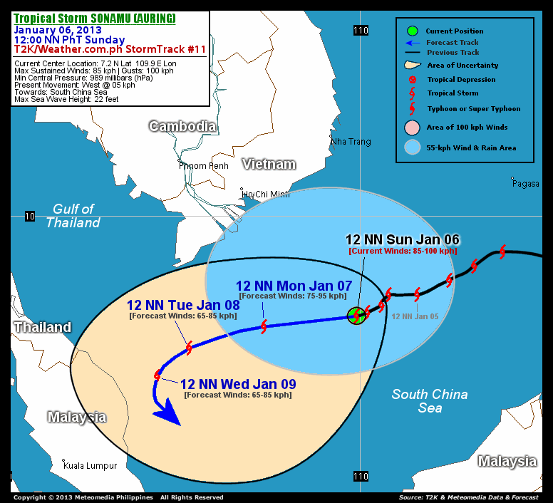
CURRENT TECHNICAL INFORMATION
Time/Date: 12:00 NN PhT Sun January 06, 2013
Class/Name: TS Sonamu (Auring)
Location of Center: 7.2º N Lat 109.9º E Lon
Distance 1: 533 km (SE) from Ho Chi Minh, Vietnam
Distance 2: 561 km (SSE) from Nha Trang, Vietnam
Distance 3: 649 km (SW) away from Pagasa Is., Spratlys
MaxWinds (1-min avg): 85 kph near the center
Peak Wind Gusts: 100 kph
Present Movement: West @ 5 kph
Towards: South China Sea
24hr Rainfall Accum (near center): Extreme [450 mm]
Minimum Central Pressure: 989 millibars (hPa)
Size (in Diameter): 390 km [Average]
Max Sea Wave Height (near center): 22 feet
Possible Storm Surge Height: 1-3 ft (0.3-0.9 m)
T2K/WP StormTracks (for Public): GIF | Google Map (Flash)

CURRENT NOAA/MTSAT-2 INFRARED SATELLITE IMAGE:

CURRENT TRACKING CHART:

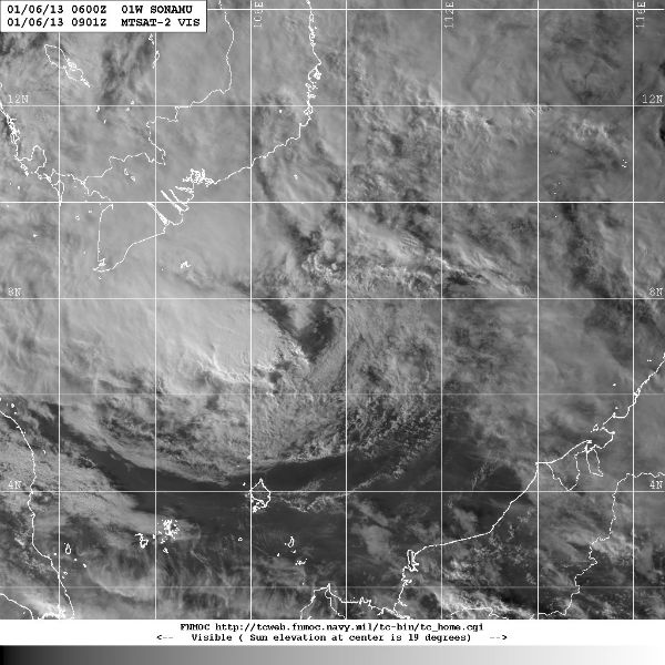 Storm region visible satellite image (Credit: MTSAT/FNMOC)
 TC Sonamu seen by MODIS/Aqua satellite on January 5, 2013 (Credit: LANCE/MODIS)
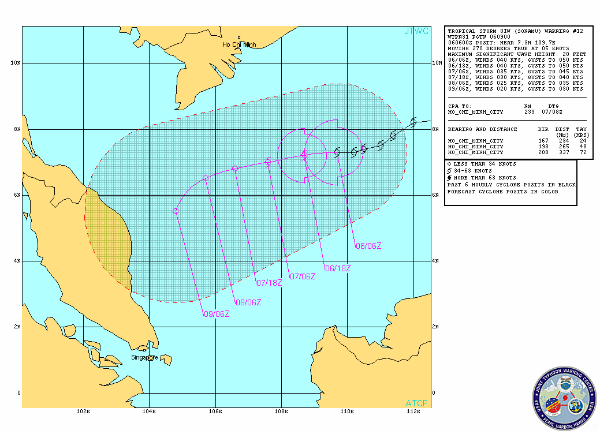 TC Sonamu forecast track by JTWC
 Current tropical disturbances (Credit: MTSAT/JTWC)
AYUH KITA BERDOA...MOGA MALAYSIA SELAMAT
Sonamu
has left the Philippines and Palawan behind and NASA satellite imagery
showed the storm intensified into a tropical storm while moving through
the easternmost South China Sea.
At
Jan. 4, 2013 at 0535 UTC (12:35 a.m. EST), a visible image of Tropical
Storm Sonamu was captured by the Moderate Resolution Imaging
Spectroradiometer (MODIS) instrument that flies aboard NASA's Aqua
satellite.
The
Joint Typhoon Warning Center (JTWC) noted that some animated infrared
satellite imagery shows central convection persisting over the low level
circulation center and some fragmented formative banding over the
northern semi-circle.
By
1500 UTC (10 a.m. EST/U.S.), Sonamu's maximum sustained winds had
increased to near 35 knots (40.2 mph/64.8 kph). Sonamu's center was
located near 8.9 north latitude and 113.2 east longitude, about 430
nautical miles (494.8 miles/ 796.4 km) east-southeast of Ho Chi Minh
City, Vietnam. Sonamu is moving to the west at 14 knots (16.1. mph/26
kph) and is expected to continue in that general direction for the next
couple of days with its center staying over open waters as it passes
southern Vietnam.
Extreme
southern Vietnam, from near Ho Chi Minh City southward may feel the
effects of the outer fringes of the storm, with gusty winds, heavy
rainfall, and rough coastal conditions.
JTWC forecasters expect that Sonamu will peak in intensity sometime on Jan. 5 and then weaken as vertical wind shear increases.
Sonamu is forecast to turn to the south-southwest and make landfall early next week in east central Malaysia.
http://www.nasa.gov/mission_pages/hurricanes/archives/2013/h2013_Sonamu.html
http://www.nasa.gov/mission_pages/hurricanes/archives/2013/h2013_Sonamu.html
NASA's Goddard Space Flight Center
Tropical storm Sonamu expected to hit east coast today
Posted on 6 January 2013 - 09:33pm
PETALING JAYA (Jan 6, 2013):
With tropical storm Sonamu expected to pound the east coast of
Peninsular Malaysia this week, all residents and fishermen in those
states have been advised to stay away from the sea.
National Security Council Secretary Datuk Mohamed Thajudeen Abdul Wahab
said in a statement on Saturday that the Malaysian Meteorological
Department (MMD) has forecast turbulent sea conditions and flooding in
low-lying areas today until Wednesday.
The storm is expected to affect Kelantan, Terengganu and Pahang.
"Those in flood-prone areas should be alert for warnings of heavy rain
and should make advance preparations for the possibility of floods,"
said Mohamed Thajudeen.
He said the public should heed orders from the authorities to evacuate their homes.
The MMD on its website has issued a warning of strong northeasterly
winds over 60 kmph with waves more than 4.5m occurring over the waters
off Kelantan, Terengganu, Samui, Condore, Reef North, Layang-Layang and
Palawan.
These conditions are expected to continue until Friday.
Tropical storm Sonamu is forecast to strike Malaysia at about 06:00 GMT on 8 January.
Sat, 5 Jan 2013 09:24 GMT
Tropical storm Sonamu is forecast to strike Malaysia at about 06:00 GMT
on 8 January.Data supplied by the US Navy and Air Force Joint Typhoon
Warning Centersuggest that the point of landfall will be near6.3 N,103.3
E.Sonamu is expected to bring 1-minute maximum sustained winds to the
region of around 64 km/h (40 mph).Wind gusts in the area may be
considerably higher.
The information above is provided for guidance only and should not be
used to make life or death decisions or decisions relating to property.
Anyone in the region who is concerned for their personal safety or
property should contact their official national weather agency or
warning centre for advice.
This alert is provided by TropicalStorm Risk (TSR) which is sponsored by Aon Benfield, Crawford & Company and University College London (UCL).
Dikeluarkan pada pukul 08:59PM, 06 Januari 2013
AMARAN KATEGORI KETIGA
AMARAN ANGIN KENCANG DAN LAUT BERGELORA
Di Perairan Laut China Selatan
Kemaskini:
Ribut Tropika (SONAMU) dikesan pada Latitud 7.5 U dan Longitud 109.3 T, pada jam 8:00 malam 6 Januari 2013, kira-kira 718 km ke Timur Laut Dungun, Terengganu dan bergerak ke arah Barat dengan perlahan.
SEKSYEN A : AMARAN ANGIN KENCANG DAN LAUT BERGELORA (KATEGORI KETIGA) - Kemaskini
Angin kencang Timur Laut dengan kelajuan dari 60 kmsj dengan ketinggian ombak melebihi 4.5 meter yang berlaku di kawasan perairan Kelantan, Terengganu, Samui, Condore, Reef North, Layang-Layang & Palawan dijangka berterusan sehingga Isnin, 7 Januari 2013.
Selain daripada itu, kawasan pantai di Kelantan & Terengganu terdedah kepada kejadian kenaikan paras air laut. Keadaan ini dijangka berterusan sehingga Isnin,7 Januari 2013.
Keadaan angin kencang dan laut bergelora ini berbahaya kepada semua aktiviti pantai dan perkapalan termasuk pekerja di pelantar minyak.
SEKSYEN B: AMARAN ANGIN KENCANG DAN LAUT BERGELORA (KATEGORI KEDUA)-Kemaskini
Angin kencang Timur Laut dengan kelajuan 50-60 kmsj dengan ombak mencapai ketinggian sehingga 4.5 meter yang berlaku di kawasan perairan Pahang, Johor Timur, Sarawak(Rejang, Mukah, Bintulu & Miri), WP Labuan, Sabah(Pedalaman, Pantai Barat & Kudat), Tioman & Reef South dijangka berterusan sehingga Jumaat, 11 Januari 2013.
Selain daripada itu, kawasan pantai di Pahang & Johor Timur terdedah kepada kejadian kenaikan paras air laut. Keadaan ini dijangka berterusan sehingga Isnin, 7 Januari 2013.
Keadaan angin kencang dan laut bergelora ini berbahaya kepada semua aktiviti perkapalan dan pantai termasuk menangkap ikan dan perkhidmatan feri.
SEKSYEN C: AMARAN ANGIN KENCANG DAN LAUT BERGELORA (KATEGORI PERTAMA)-Kemaskini
Angin kencang Timur Laut dengan kelajuan 40-50 kmsj dengan ombak mencapai ketinggian sehingga 3.5 meter yang berlaku di kawasan perairan Sarawak(Kuching), Sabah(Sandakan), Bunguran & Sulu dijangka berterusan sehingga Jumaat, 11 Januari 2013.
Keadaan angin kencang dan laut bergelora ini adalah berbahaya kepada bot-bot kecil, rekreasi laut dan sukan laut.
SEKSYEN D: AMARAN RIBUT PETIR MENYELURUH-Kemaskini
i) Aktiviti ribut petir yang berlaku di perairan Condore & Palawan dijangka berterusan sehingga malam, Ahad, 6 Januari 2013.
Pada masa yang sama, angin kencang dengan kelajuan melebihi 60 kmsj dengan ombak mencapai ketinggian melebihi 4.5 meter, adalah berbahaya kepada semua aktiviti pantai dan perkapalan termasuk pekerja di pelantar minyak.
ii) Aktiviti ribut petir yang berlaku di perairan Sabah (Kudat dan Pantai Barat) dijangka berterusan sehingga malam, Ahad, 6 Januari 2013.
Pada masa yang sama, angin kencang dengan kelajuan 50-60 kmsj dengan ombak mencapai ketinggian sehingga 4.5 meter, adalah berbahaya kepada semua aktiviti perkapalan dan pantai termasuk menangkap ikan dan perkhidmatan feri.
iii) Aktiviti ribut petir yang berlaku di kawasan perairan Sabah (Sandakan) & Sulu dijangka berterusan sehingga malam, Ahad, 6 Januari 2013.
Pada masa yang sama, angin kencang dengan kelajuan 40-50 kmsj dengan ombak mencapai ketinggian sehingga 3.5 meter, adalah berbahaya kepada bot-bot kecil, rekreasi laut dan sukan laut.
Dikemaskini pada 06 Januari 2013, jam 08:59PM
CURRENT TECHNICAL INFORMATION
Time/Date: 12:00 NN PhT Sun January 06, 2013
Class/Name: TS Sonamu (Auring)
Location of Center: 7.2º N Lat 109.9º E Lon
Distance 1: 533 km (SE) from Ho Chi Minh, Vietnam
Distance 2: 561 km (SSE) from Nha Trang, Vietnam
Distance 3: 649 km (SW) away from Pagasa Is., Spratlys
MaxWinds (1-min avg): 85 kph near the center
Peak Wind Gusts: 100 kph
Present Movement: West @ 5 kph
Towards: South China Sea
24hr Rainfall Accum (near center): Extreme [450 mm]
Minimum Central Pressure: 989 millibars (hPa)
Size (in Diameter): 390 km [Average]
Max Sea Wave Height (near center): 22 feet
Possible Storm Surge Height: 1-3 ft (0.3-0.9 m)
T2K/WP StormTracks (for Public): GIF | Google Map (Flash)
__________________________________________________________________________________________________
CURRENT NOAA/MTSAT-2 SATELLITE ANIMATION:
CURRENT NOAA/MTSAT-2 SATELLITE ANIMATION:
CURRENT NOAA/MTSAT-2 INFRARED SATELLITE IMAGE:
CURRENT TRACKING CHART:
_____________________________________________________________________________
NOTE:
>> To
know the meteorological terminologies and acronyms used on this
update visit the
ff: http://typhoon2000.ph/tcterm.htm http://www.nhc.noaa.gov/aboutgloss.shtml
http://www.nhc.noaa.gov/acronyms.shtml
__________________________________________________________________________________________For
the complete details on TS SONAMU (AURING)...go visit our website
@:> http://www.typhoon2000.com
> http://www.maybagyo.com
> http://www.typhoon2000.ph
:: Kindly view our site's disclaimer
at: http://www.typhoon2000.ph/disclaimer.htm
JTWC and JMA upgraded to a Sonamu to a severe Tropical Storm yesterday.
The system continues to move across the South China Sea, for now
staying south of Vietnam. Heavy rains and strong winds remain offshore
although light rains may affect Southern Vietnam in the next 24 hours.
Storm region visible satellite image (Credit: MTSAT/FNMOC)
According to latest report by JTWC, Tropical Storm Sonamu was located
approximately 270 nm southeast of Ho Chi Minh city, Vietnam, has tracked
west-southwestward at 5 knots. As Sonamu has been tracking westward, it
has started to slow in the weakening steering environment. Sea surface
temperatures are currently favorable for further development (28 to 29
degrees Celsius).
TC Sonamu seen by MODIS/Aqua satellite on January 5, 2013 (Credit: LANCE/MODIS)
Sonamu is forecast to begin weakening by Monday as it heads towards the
Malay Peninsula. It will track slowly along the southern periphery of
the low- to mid-level subtropical ridge over the Andaman Aea in a
generally westward direction through the next three days. It is
forecasted to weaken to a Tropical Depression before making landfall
near Thailand and Malaysia. A large swath of vertical wind shear
associated with the North East monsoon will rapidly weaken the system.
TC Sonamu forecast track by JTWC
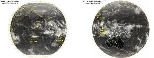
Two more areas of low pressure formed along Inter-Tropical Convergence
Zone – the trail of convection running eastward from the Philippines.
They could potentially develop into weak cyclones next week.
Current tropical disturbances (Credit: MTSAT/JTWC)
Satellite Animations
- Storm-Centered Infrared (MTSAT; NOAA/SSD)
- Storm-Centered Infrared (Aviation Color Enhancement) (MTSAT; NOAA/SSD)
- Storm-Centered Water Vapor (MTSAT; NOAA/SSD)
- Storm-Centered Visible (MTSAT; NOAA/SSD)
- Storm-Centered Visible (Colorized) (MTSAT; NOAA/SSD)
- West Pacific/South China Sea Infrared (MTSAT2; NOAA)
- West Pacific/South China Sea Enhanced Infrared (MTSAT2; NOAA)
- West Pacific/South China Sea Water Vapor (MTSAT2; NOAA)


(1).png)

No comments
Post a Comment